Dolomites Tre Cime: The Iconic Three Peaks of the Italian Alps (2026 Guide)
If you searched for Dolomites Tre Cime (Tre Cime di Lavaredo / Three Peaks of Lavaredo), you’re likely planning a Dolomites trip and want one practical answer: is it worth the drive, what’s the best hiking route, and how do you avoid wasting time with parking and crowds?
🏆 Quick Summary: Tre Cime Essentials
- ⛰️ The Icon: Three jagged limestone towers that are the ultimate symbol of the Italian Dolomites.
- 🥾 The Route: The classic loop from Rifugio Auronzo to Rifugio Locatelli (approx. 3–5 hours).
- 🚗 Access: Reached via a toll road from Misurina; parking fills up very early (before 8 AM).
- 🗓️ Best Season: Late June to September for snow-free trails and blooming meadows.
- 🛡️ 2026 Strategy: Arrive for sunrise to secure a spot and witness the “Enrosadira” (peaks turning pink).
“Standing beneath the limestone giants of Tre Cime, the wind carries the distant chime of cowbells across the high alpine plateau, while the jagged peaks shift from pale gold to deep sapphire as the sun traces its arc across the Italian sky.”
Why Dolomites Tre Cime Are the Most Iconic Hike
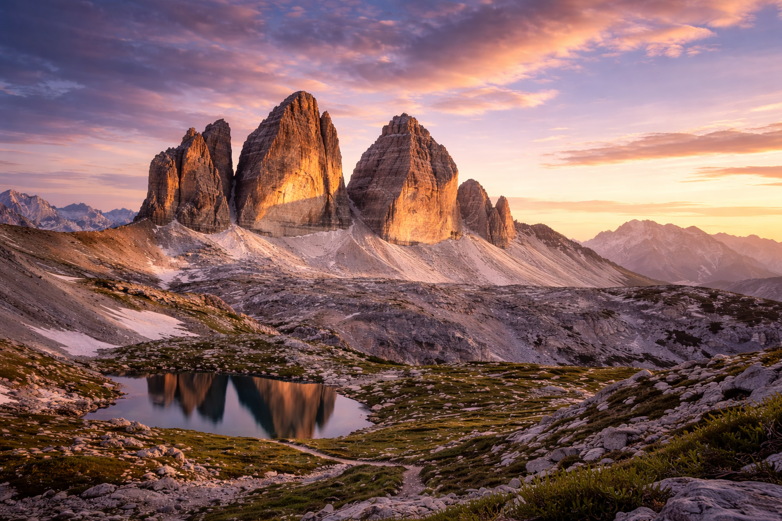
Dolomites Tre Cime, also known as the Three Peaks of Lavaredo, are the Dolomites’ most famous natural symbol—and in person, they feel even more dramatic than the photos. The jagged limestone towers rise like stone guardians above alpine meadows. This isn’t just a “nice mountain view.” Tre Cime is a full experience: crisp air, rifugi culture, panoramic hiking, and the kind of landscape that makes you stop walking just to stare. If you only choose one signature hike in the Dolomites, this is the one that delivers the most impact with the least navigation stress.
The Contextual Strategy: Beating the Crowds
The “Contextual Strategy” for Dolomites Tre Cime is simple but non-negotiable: Timing is everything. In 2026, the popularity of this site means that arriving at 10 AM is a recipe for frustration. To truly master this visit, treat it as a “Sunrise Mission.” By parking at Rifugio Auronzo at 6:30 AM, you not only guarantee a parking spot but also experience the trails in a profound silence that the mid-day crowds never get to hear. This early start transforms a “tourist stop” into a soulful mountain pilgrimage.
Key Information Matrix: Tre Cime di Lavaredo (2026)
| Category | Details for Visitors |
|---|---|
| Location | Auronzo di Cadore, Dolomites, Northern Italy |
| Toll Road Fee | Approx. €30 per car (Price updated for 2026) |
| Main Gateway | Rifugio Auronzo (End of the toll road) |
| Hike Difficulty | Moderate (Paved gravel & uneven rock sections) |
A vs B: Sunrise Arrival vs. Afternoon Visit
| Feature | Sunrise (The Expert Choice) | Afternoon (The Relaxed Choice) |
|---|---|---|
| Parking | Guaranteed (if before 7:30 AM) | High risk of road closure / Long lines |
| Light Quality | Golden hour, perfect for photography | Flat light or harsh shadows |
| Trail Vibe | Quiet, serene, alpine birdsong | Social, busy, high-energy crowds |
🟢 Insider Hacks: Mastering the Peaks
- The “Reverse” Loop: Most people walk to the right toward Rifugio Lavaredo. If you want a slightly more secluded start, consider the path toward the Langalm hut first.
- Cash is King: While the toll booth takes cards, the smaller mountain huts (rifugi) often have spotty internet. Bring Euros for that essential polenta and speck lunch.
- The Best Angle: The most famous view isn’t from the parking lot; it’s from Rifugio Locatelli (Drei Zinnen Hütte). Don’t stop early—keep walking!
- Nearby Lake Stop: On your drive back down, stop at Lago di Misurina. The reflection of the Sorapis range in the water is the perfect post-hike cooldown.
Step-by-Step High-Impact Visit Route
- Start at Rifugio Auronzo: Follow trail 101. It’s a wide, flat gravel path to start, perfect for warming up.
- Forcella Lavaredo: Reach the “saddle.” This is your first “wow” moment where the Three Peaks reveal their vertical scale.
- The Traverse to Locatelli: Continue toward Rifugio Locatelli. This section offers the panoramic “postcard” view of the three distinct towers.
- Lunch at the Hut: Grab a traditional Tyrolean dish at Rifugio Locatelli while staring directly at the north faces.
- The Valley Loop: Return via trail 105, which dips into the meadows below the peaks for a completely different perspective.
⚠️ Warning: Common Visitor Mistakes
- Sneaker Regret: This is a mountain trail, not a city park. Sturdy hiking shoes with grip are essential; the gravel sections can be very slippery on the descent.
- Weather Hubris: The weather at 2,300 meters changes in minutes. Even if it’s 25°C in the valley, a windproof jacket is mandatory for the ridges.
- The Toll Road “Full” Sign: Once the parking at the top is full, they close the gate at the bottom. Do not assume you can just “wait in line”—they often stop traffic for hours.
Location Map: Tre Cime di Lavaredo
FAQ: Dolomites Tre Cime
Absolutely. While expensive, the toll road saves you a grueling 2-hour uphill hike, giving you more energy to enjoy the spectacular high-altitude loop.
Most hikers complete the standard circuit in 3 to 5 hours, including stops for photography and a light lunch at a rifugio.
The toll road is closed in winter. Access is only possible via snowmobile service, snowshoes, or ski touring for experienced alpine travelers.
Yes, the main trail (101) is wide and relatively flat. However, the full loop (105) has some elevation gain and rocky sections that require basic fitness.
Explore More Italian Icons:
- ➜ Venice Charm: Witness the architectural magic of the Rialto Bridge Venice.
- ➜ Ancient Wonder: Step inside the historic Bridge of Sighs Venice.
- ➜ Island Sun: Relax on the pristine sands of Cagliari Poetto Beach.
- 🏛️ Official Site: Tre Cime di Lavaredo Official Tourism Portal
Author Note: This guide was meticulously updated in February 2026 to reflect the latest toll pricing and trail conditions for Dolomites Tre Cime.